Measures for the Shapes of Impact Craters
How to Quantify the Shape of an Area
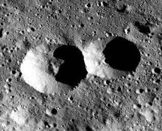
In a previous post, I mentioned that Fred Calef and colleagues (2009) identified several quantitative measures helpful in distinguishing secondary impact craters from primaries on the surface of Mars. Two of the useful measures that should also be useful for evaluating craters on Ceres are the Form Ratio and the Circularity Ratio.Described by Keith Selkirk (1982) as measures for quantitatively representing the shape of geographic areas on Earth, such as drainage basins, they are also useful for determining the "compactness" of geomorphological features elsewhere in the Solar System.
Circularity Ratio
Circularity is a ratio of a region's area to its perimeter. Selkirk observes that a longer perimeter relative to a shape's area results in a more convoluted shape. A shorter perimeter relative to the area is more compact, with the ideal compactness occurring with a circle.Here is the basic formula:
circularity_ratio = area / perimeter²
For a circle, this results in a value of approximately 0.08. To get the maximum possible value to be equal to 1, Selkirk multiples the whole thing by 4π, resulting in the final form:
circularity_ratio = 4π * area / perimeter²
Form Ratio
The form ratio is another measure of compactness, but uses the distance between a shape's two most distant points in comparison to its area. If you consider two rectangles with the same area: a square (10 x 10), and a rectangle whose length is four times its width (5 x 20). The length between the two most distant point in the square is 14.14, while the measure between two two most distant points in the long rectangle is approximately 20.6. Same area, but quite different distal lengths. And again, a higher ratio indicates higher compactness.Here is the formula:
form_ratio = (4 * area) / (π * distal_length²)
By placing π as a factor in the denominator, the equation yields a ratio value between zero and one, with one being the form ratio for a circle.
These formulas can be calculated for impact craters shown in planetary images or maps using the Custom Shape Layer in JMARS, and in a future blog post I will describe how to do it.
References:
- Selkirk, K. E. (1982). Pattern and place: an introduction to the mathematics of geography. Cambridge University Press.
- Calef, F. J., Herrick, R. R., & Sharpton, V. L. (2009). Geomorphic analysis of small rayed craters on Mars: Examining primary versus secondary impacts. Journal of Geophysical Research: Planets, 114(E10). html


Comments
Post a Comment